


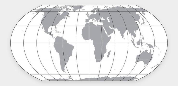
The African Union has thrown its weight behind a campaign for a more accurate world map that shows how big Africa really is. Popular maps in use often show that Africa is roughly the size of Greenland when, in fact, it is nearly 14 times bigger.
I have explored some of the politics of world maps on social media.
The AU’s concerns are hardly new. In the 1970s and 1980s, the same debate raged fiercely until it was resolved in favor of the maxim, “use the map that is best for what you want to do.”
In simple terms, every world map model reflects the constraint that in converting a spherical Earth to a flat chart, there would be trade-offs.
Take the new map model the AU is backing, for instance. A system created by an Australian professor and two Americans, a software developer and retired cartographer, the Equal Earth Projection prides itself on restoring Africa’s true size without falling into the trap of similar systems, like the Robinson model it is inspired by, which has serious angular and other inaccuracies.
Yet, there are a wide range of tradeoffs.
Focusing deliberately on the digital environment, I was able to show that there are areas where the Equal Earth model underperforms the incumbent Web Mercator. For example, there is greater distortion of shapes, angles, and lines in the newly-backed map compared to that in the existing one.
The question, then, is: Why didn’t the AU launch a consultation with Africa’s digital and mapping communities to better evaluate the pros and cons of the Equal Earth system? There are more than 20 other popular models. Why settle on one without the inputs of those in Africa closest to the policy and technical issues involved?
My answer is that the AU is just replaying a type of standard governance playbook I’ve seen in my home country of Ghana. This is when the political form of issues always take precedence over the required policy plumbing and substructure, even though it is the latter that actually build the real solutions up. The result is an absence of “policy accountability” even where there is “political accountability,” a gap I call “katanomic.”
It leads to a situation where African elites always prioritize geopolitics over geopolicy.
I don’t dispute the reality of “standards geopolitics.” It is not for nothing that the World Geodetic System itself is a standard developed by the United States’ National Geospatial-Intelligence Agency (NGA), a military affair. America is an undeniable cosmo-hegemon that controls the GPS network, another military affair that many of our apps and lives depend upon in Africa.
But as I explain elsewhere, there are still global policy bodies, and many in the African diaspora with the chops to influence those bodies, if only the AU will take the policy mobilization aspect of its work as seriously as it does the political flag-hoisting.
Because without getting the policy side of pan-African integration and solidarity working, Africa will always falter at geopolitics.
Bright Simons is an honorary vice president at IMANI, an Accra-based think tank, and a visiting senior fellow at ODI Global in London.